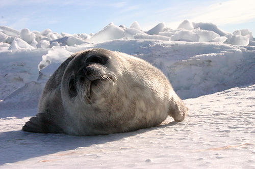
Scientists are asking the public to look through thousands of satellite images of Antarctica to assist in the first-ever, comprehensive count of Weddell seals. Counting seals will help scientists better protect and conserve the pristine Ross Sea and wildlife in the area.
Weddell seals are important to the Southern Ocean ecosystem and have been studied since the early 1900s. However, no one has been able to do a comprehensive count of the seals due to the harsh Antarctic weather and remote locations in which the seals live. Now, high-resolution satellite images provide a solution—counting seals on satellite images—but there are too many images for scientists to handle alone.
The citizen science project, called Satellites Over Seals (SOS), focuses on about 300 miles of Antarctic coastline along the Ross Sea. Anyone can view the satellite images online from anywhere in the world and help with the count. Crowdsourcing research in this way allows researchers to efficiently and effectively comb through large amounts of data using the public’s help.
“We couldn’t do this without help from citizen scientists and that’s why partnering with the crowdsourcing website Tomnod to do this project was critical,” said Michelle LaRue, a research ecologist in the University of Minnesota’s Department of Earth Sciences and lead researcher on this project. “Even though our research team has people who are Weddell seal experts and know how to count seals on the images, it would take years for us to count them all.
“By surveying the sea ice habitat frequented by the seals, the public will not only assist in the pursuit of science, but will help us better protect and conserve the most pristine piece of ocean on the planet—the Ross Sea,” LaRue added.
Weddell seals are one of Antarctica’s most iconic species. In addition to being undeniably charismatic, they are the southern-most mammal in the world, can live up to 30 years, and are perfectly adapted to living in some of the harshest conditions on the planet.
But Weddell seals are important for another reason. They are what scientists call an “indicator species” because they prey on Chilean seabass, called Antarctic toothfish by scientists. These fish are a high-end delicacy in many upscale restaurants around the world, and commercial fishing has increased in the Ross Sea in the last 20 years due to this demand. By counting seals on satellite imagery, scientists hope to learn how fishing in the Ross Sea for Antarctic toothfish is affecting the number of seals and the entire ecosystem over time. The treaty under which the fishing occurs dictates that dependent species not be deprived of their resources.
“Despite having little information about Antarctic toothfish, we can gain insight into the health of the Ross Sea by understanding how Weddell seal populations are doing,” LaRue said. “By counting seals on satellite imagery, we hope to learn how the Ross Sea is functioning as fishing continues. Using the satellite imagery, we’ve already seen that in a couple of local areas, seal numbers have drastically changed, but we need a broader perspective to better understand what might be going on.”
This research is funded by the National Science Foundation and is a joint effort between the University of Minnesota, University of Colorado at Boulder, H.T. Harvey & Associates Ecological Consultants, Point Blue Conservation Science and DigitalGlobe.
Description:Weddell seals will show up on the satellite images as black dots on the ice.
Image credit: DigitalGlobeSource:Digital GlobeNews Image:
- Categories:
- Science and Technology


