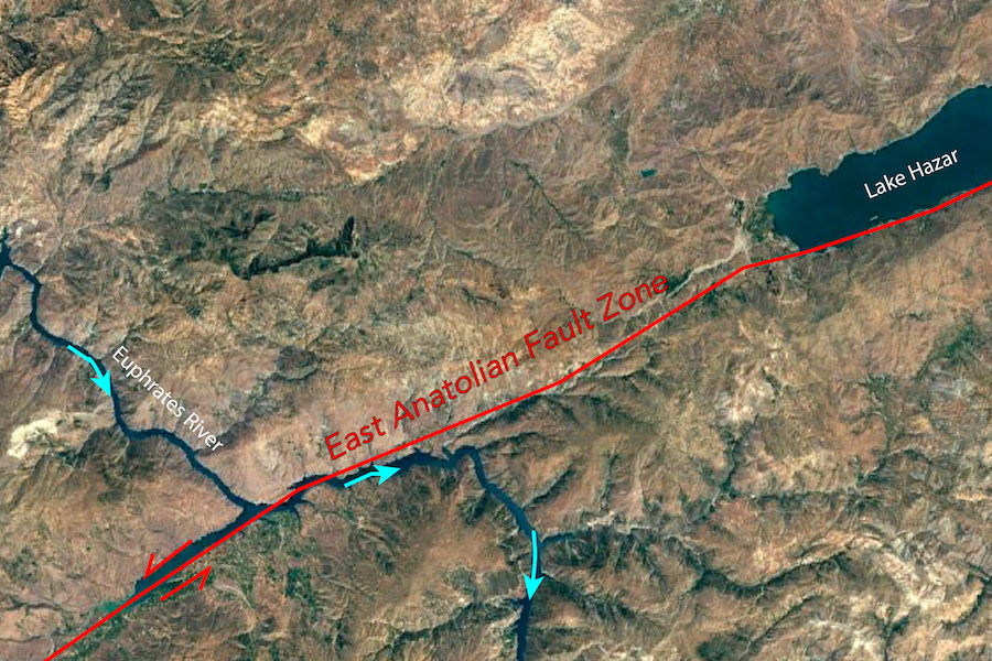
An international team led by the University of Minnesota has, for the first time, accurately determined the age and formation process of the East Anatolian fault, the site of two devastating earthquakes in Turkey and Syria in February 2023.
The East Anatolian fault runs from eastern to south-central Turkey and was involved in the creation of the Anatolian tectonic plate.
While the researchers’ findings won’t help predict timing or size of earthquakes, it allows geologists to learn more about how long the area has been seismically active and how major earthquakes have shaped the landscape over time, which can help drive decision making for infrastructure and placement of homes.
Their paper is published in Geology, a leading peer-reviewed academic journal covering the geosciences fields published by the Geological Society of America.
The faults we see on the Earth’s surface are cracks caused by the movements of the planet’s massive tectonic plates. These movements cause stress to build up and the release of that stress causes the earthquakes humans experience on the surface.
“There are lots of tectonic plates in the world,” said Donna Whitney, lead author of the paper and a professor in the College of Science and Engineering. “They've changed shape and size and position over time, but we very seldom get to see one form. The Anatolian plate formed fairly recently in a geological sense, so the processes that formed it are easier for us to deduce from studying the geology. There's been a lot of debate about the age of the Anatolian plate and the East Anatolian fault, but we were able to show with our data that it likely formed five million years ago.”
The researchers’ findings originated from a National Science Foundation-funded project Whitney instigated called Continental Dynamics-Central Anatolian Tectonics (CD-CAT), which brought together researchers from multiple geosciences disciplines and countries to study the Anatolian plate and its associated fault zones.
Whitney and her team began studying the Anatolian plate in 2011 because they found evidence that for tens of millions of years, the middle of the plate had been deforming — a process that typically only happens at the edges of tectonic plates. Five million years ago, there was a dramatic change. Since that time, nearly all the tectonic movement has been focused along two major earthquake-generating faults: the North Anatolian Fault and the East Anatolian Fault.
By dating the cooling of the rocks in the East Anatolian fault and looking at seismic data collected during the project, the CD-CAT researchers determined the structure of the continents and underlying mantle in the region and confirmed that this five-million-year point marked the creation of the Anatolian plate.
“Knowing the seismic history of this area is really important for anticipating disasters related to the way that people interact with the landscape,” Whitney said. “We can't predict that there's going to be a magnitude ‘X’ earthquake on this fault at a certain time, but we can get a sense of the fault’s activity in the past, how big the events have been, and how much fault motion has affected the landscape. We need to understand these structures because people live near them, and there's infrastructure near them.”
In addition to Whitney, two of the major contributors to the study were seismologist Jonathan Delph, who is an assistant professor at Purdue University, and University of Arizona geochronologist Stuart Thomson, who handled much of the age data analysis.
- Categories:
- Science and Technology
- Earth Sciences


